


Fierce Snow and Ice Storm Approaches N.J., Forecasts Adjust for Rising Ice Threat
A significant winter storm is poised to impact New Jersey, beginning tonight. The National Weather Service (NWS) has heightened concerns over the potential for hazardous snow and ice conditions across the state. The storm is expected to bring dangerous freezing rain and substantial snowfall, resulting in major travel disruptions and possible power outages.
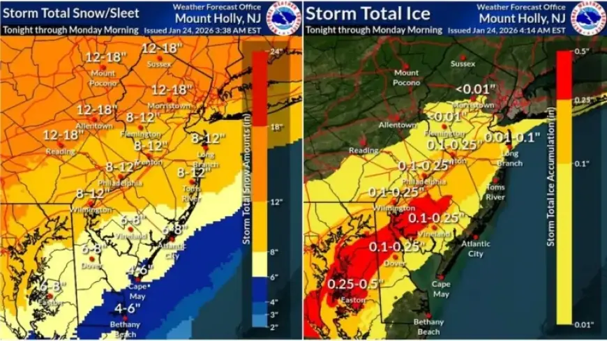
Storm Forecast Overview
The forecast indicates that northern New Jersey could see snowfall totals approaching 18 inches. Southern regions may experience up to three-tenths of an inch of ice layered atop substantial snowfall.
- Northern New Jersey: 12 to 18 inches of snow expected.
- Southern New Jersey: Ice accumulation between 0.1 and 0.3 inches.
Timing and Impact
Snow is anticipated to begin overnight, with the heaviest accumulation expected during the day on Sunday. Accumulation rates may reach as high as 1 to 2 inches per hour.
This storm poses a dual threat, combining heavy snow with widespread ice conditions. The NWS emphasized the potential for travel to become nearly impossible, urging residents to prepare for significant disruptions.
Emergency Measures
In response to the anticipated conditions, Governor Mikie Sherrill declared a state of emergency effective at 5 PM on Saturday. A travel ban for commercial vehicles will be enforced on major highways, reinforcing the message for residents to avoid traveling during the storm.
Regional Breakdown of Storm Warnings
The following counties are under specific storm warnings with expected impacts:
| County | Warning Period | Expected Accumulations |
|---|---|---|
| Burlington, Camden, etc. | 7 PM Saturday to 1 PM Monday | 7 to 13 inches of snow, up to 0.3 inches of ice |
| Bergen, Essex, etc. | 3 AM Sunday to 6 PM Monday | 10 to 14 inches of snow, potential sleet |
| Western Passaic | 3 AM Sunday to 6 PM Monday | 12 to 16 inches of snow |
| Atlantic and Cape May | 7 PM Saturday to 7 AM Monday | 4 to 8 inches of snow, ice up to 0.1 inches |
| Sussex and Warren | 1 AM Saturday to 1 PM Monday | 11 to 15 inches of snow |
Ongoing Weather Conditions
As the storm unfolds, cold weather advisories remain in effect, with temperatures expected to dip into the upper teens and low 20s. Wind chills may plummet to below zero across much of the state.
This polar air mass will linger, sustaining frigid temperatures throughout the week. Post-storm conditions may hinder melting, leading to prolonged icy conditions.
Residents are urged to stay updated on forecasts, prioritize safety, and remain indoors wherever possible. The situation is still developing, and updates will be essential to navigate these severe winter conditions responsibly.