


Kansas City Snowfall Forecast Increases: Find Out the New Timing
The upcoming winter storm is set to impact Kansas City with significant snowfall, surpassing previous expectations. The National Weather Service (NWS) warns that accumulations could reach between 8 to 9 inches in the city.
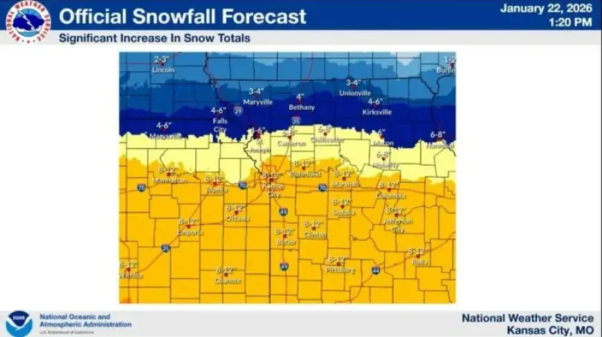
Kansas City Snowfall Forecast Increases
According to NWS meteorologist Brent Pesel, the trajectory of the storm has shifted northward. This adjustment means Kansas City will likely receive greater snowfall than initially predicted.
Snow Accumulation Estimates
Latest forecasts indicate various expected snowfall amounts:
- Kansas City: 8 to 9 inches
- Farther south: 11 to 12 inches
- Northern Missouri (between I-70 and U.S. 36): 6 to 8 inches
- Farther north: Less than 4 inches
Pesel emphasized that the snow will likely be light and fluffy. However, with wind speeds of 20 to 25 mph and gusts up to 30 mph, there is a substantial risk of blowing snow, which could hinder visibility and affect travel conditions throughout Saturday.
Timing of the Snowfall
The snowfall is projected to start late Friday night, continuing into early Saturday morning. Here are key timing details:
- Areas south and east of Kansas City: Snow may begin between 9 p.m. and midnight Friday.
- Kansas City metro: Snow arrival expected between midnight and 3 a.m. Saturday.
- North and east of Kansas City: Snow could start between 3 a.m. and 6 a.m.
Pesel noted that a dry air mass might delay the onset of snow by 2 to 3 hours. If the snow starts later, it could result in lower totals, whereas an earlier onset might increase accumulations.
Storm Duration and Cold Weather
The heaviest snow is anticipated on Saturday morning through midday, with potential bursts of heavier snowfall into the afternoon. The storm is expected to linger before moving out of the region late Saturday night into Sunday morning.
Additionally, dangerously cold conditions will persist over the weekend. The wind chill in the Kansas City area could remain below zero for over 48 hours, lasting until Monday morning.
As the storm approaches, residents are advised to prepare for challenging weather conditions and monitor forecasts for updates. For more information, visit Filmogaz.com.