


Arizona High Country Braces for Snowfall on First Alert Weather Day
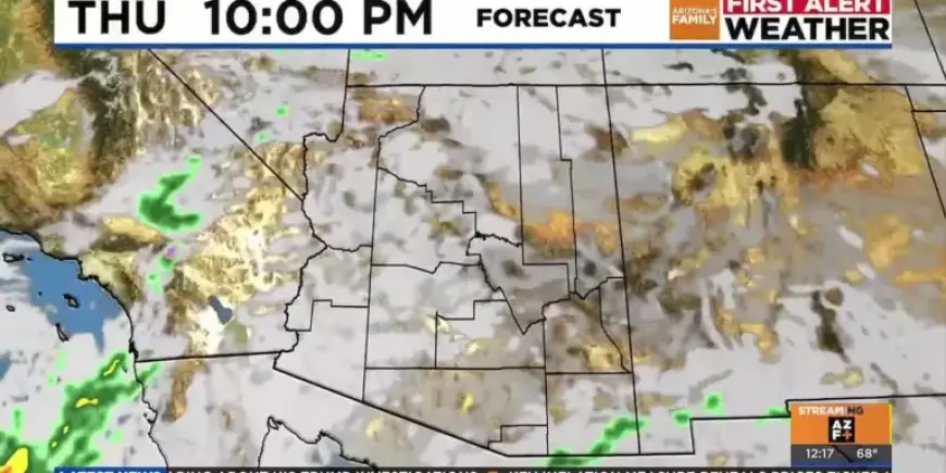
Arizona’s high country is preparing for significant snowfall as a low-pressure system draws closer. This system is expected to bring moisture, resulting in varied weather conditions across the state. As temperatures are projected to cool over the weekend, residents are bracing for the weather changes.
Weather Update for Arizona’s High Country
This Friday marks the onset of Arizona’s First Alert Weather Day, with the most promising chance for rain occurring on Saturday. Light sprinkles may occur on Friday, but more substantial rainfall is anticipated Friday night into Saturday morning.
Forecast Overview
- Average highs to be in the mid to upper 60s from Friday to Sunday.
- Overall rainfall totals range from a tenth to a quarter of an inch in lower desert areas.
- Expected light showers in central and southeastern Arizona on Friday.
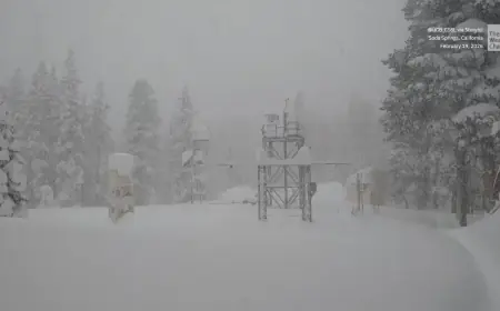
Snowfall Projections in the High Country
In the high country, snowfall is expected to be most notable on Friday evening into Saturday morning. Snow levels are forecasted to be between 6500 and 7000 feet initially, dropping further by Saturday.
- Accumulation is projected to be above 7000 feet.
- Pinetop may see between 3 to 5 inches of snow.
- Higher elevations in the White Mountains could accumulate 10 to 12 inches.
Winter Weather Advisory
A Winter Weather Advisory is currently in effect from Friday to Sunday morning for parts of eastern Arizona, including key areas like Pinetop, Show Low, and Greer. Residents should prepare for winter weather conditions, particularly in the higher elevations.
Looking Ahead
As we head into next week, the forecast indicates a return to dry conditions by Sunday. Temperatures are expected to rise again, reaching the mid to lower 70s throughout the week.
Stay tuned to Filmogaz.com for ongoing weather updates and safety alerts as Arizona’s high country braces for this winter weather system.