


Boston Braces for Major Snowstorm: Over 20 Inches Expected This Weekend
The Boston area is preparing for a significant winter storm expected to impact the region this weekend. Forecasts predict over 20 inches of snow, driven by an Arctic air mass that will lead to dangerously low temperatures.
Boston Faces Major Snowstorm: Key Details
According to the National Weather Service, winter storm watches and warnings cover over 2,000 miles, extending from the Southwest to New England. Major cities from the Texas Panhandle to the Northeast will see substantial snowfall, with accumulations expected to exceed a foot in numerous areas.
Severe Cold and Chilling Winds
The cold air begins to filter in Friday evening, ushering in dangerously low temperatures. By Saturday morning, temperatures across southern New England could plummet between -10 and 10 degrees Fahrenheit. Wind chills will be particularly treacherous, ranging from -25 to -15 degrees. Under these conditions, exposed skin could suffer frostbite in less than 30 minutes.
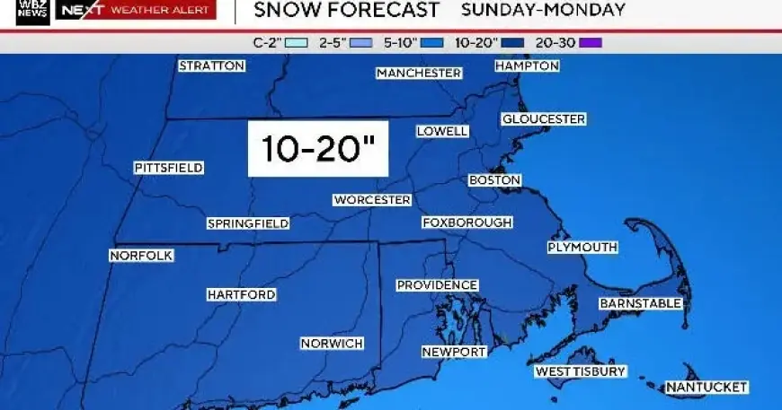
Snowfall Projections for Massachusetts
As the storm approaches, winter storm watches are already in effect for all of southern New England, beginning early Sunday morning through Monday evening. Snow is anticipated to start mid to late Sunday morning, becoming denser and heavier as the day progresses. The storm’s peak intensity is expected from 5 p.m. Sunday to 5 a.m. Monday.
Travel conditions are expected to deteriorate by Sunday late afternoon, with the most hazardous period occurring overnight. Motorists should exercise caution, particularly from 7 p.m. to 7 a.m. when snow accumulation will be at its worst.
How Much Snow Can Boston Expect?
- General Accumulation: A widespread forecast suggests that southern New England may see 10 to 20 inches of snow.
- Snow Characteristics: The forecasted snowfall is expected to be light and fluffy, making it easier to clear.
- Power Outages: Reduced stickiness of the snow is likely to keep power outages low.
- Accumulation Timing: Most snow accumulation will occur overnight Sunday into early Monday.
Variability in Snow Totals
Several factors may influence the final snow accumulation totals:
- Mix with Ice/Rain: Areas like Cape Cod may experience a mix, which could reduce overall snow totals.
- Local Front Phenomena: A coastal front might create temperature differences across the region. This could result in varied snow types and amounts.
- Frigid Conditions: Cooler temperatures on the western side of the front could lead to fluffier snow, increasing totals.
Possible Blizzard Conditions
Fortunately, the storm is not expected to bring significant winds, reducing the likelihood of blizzard conditions. Sustained winds or frequent gusts above 35 mph, paired with low visibility, are essential for blizzard classification. While coastal gusts may reach 20-40 mph, blizzard conditions are unlikely.
As the storm approaches, stay informed with updates from Filmogaz.com and local news sources to prepare adequately.