


Arizona Braces for Rain and Snow on First Alert Days
Arizona is gearing up for significant weather changes over the weekend, marked by the first alert days for rain and snow. Today, residents in the Valley can expect mild temperatures in the mid-70s complemented by mostly cloudy skies. As the day progresses, there may be some breaks in the clouds, allowing glimpses of sunshine.
Upcoming Weather Events
From Friday through Saturday, an area of low pressure will traverse the state, leading to scattered light rain. The forecast indicates:
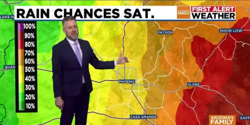
- Friday: Rain chances at 20%, increasing to 40% by night.
- Saturday: Rain chances rise to 50%, then drop to 20% Saturday night.
There is a notable risk of thunderstorms, along with potential for small hail, lightning, and gusty winds during this period. The most significant likelihood for measurable rain will occur from Friday night into Saturday morning.
Snowfall Predictions
In Arizona’s high country, snow levels will initially be elevated at 6,500 to 7,000 feet on Friday. However, they are expected to decrease to around 5,000 feet by Saturday. Flagstaff is likely to see a few inches of snow, and the White Mountains may experience heavier snowfall. A Winter Storm Watch is in effect for elevations above 7,000 feet, active from Friday afternoon until Sunday morning.
Temperature Outlook
Expect temperature fluctuations as the weekend approaches:
- Friday: Highs in the low 70s.
- Saturday: Expected temperatures in the mid-60s.
- Sunday: Predicted to be sunny and dry, with similar weather extending into the middle of next week.
Residents are advised to stay updated on weather conditions as the state prepares for a notable transition that includes rain and snow.